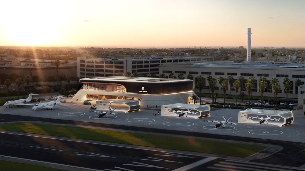
More than 1,000 wind tunnels operate worldwide in aerospace, transportation, and construction, yet none address the chaos below 1,000 meters that urban drones and air taxis must navigate. Channel News Asia's October 2025 investigation into China's low-altitude economy uncovered why: Shenzhen's ShenSi Lab operates the first wind tunnel designed expressly to test drones under the varying wind conditions they'll encounter during urban operations. This facility doesn't just test drones. It tests them under the specific atmospheric conditions that urban flight demands.
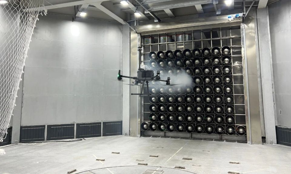
Walk into ShenSi Lab on Danxia Road, Longhua District, Shenzhen. You'll find an 18-meter-diameter wind tunnel chamber with 81 high-power fans, unmatched globally. The setup simulates what a delivery drone faces when forced between two skyscrapers and into a downtown downdraft. The system adjusts airflow in two seconds flat. Conventional wind tunnels take minutes to stabilize. That delay means most aircraft would have already nose-dived onto city pavement.
Industry forecasting for urban drones and eVTOLs currently achieves 30 percent readiness in marginal weather conditions. Don Berchoff, a four-decade aviation weather veteran at TruWeather Solutions, established that benchmark in 2024. Thirty percent. That's where the global field currently stands in predicting wind around buildings.
Urban canyon winds swing directions within seconds. Heat islands spawn thermals that flip quadcopters without warning. Wake vortices linger even after prevailing winds shift. Below 500 feet, terrain and buildings disrupt airflow in unpredictable patterns. The boundary layer up to 5,000 feet shifts dramatically with location. A drone flying ten miles beyond visual range encounters three fog banks and two wind shifts above the treetops, none captured by standard models. Research at UC Berkeley and NASA confirmed that urban heat islands and land surface variations increase turbulence, raising the risk on urban routes.
Airport stations like the one at Shenzhen Bao'an gauge open-field conditions for airliners. The drone flying between Ping An Finance Centre and Shun Hing Square works within a distinct regime. Wind speed doubles, direction turns 90 degrees, visibility slides from clear to fogbound in just three blocks.
North Carolina drone operators cancel up to 40 percent of flights due to weather. Of those, 30 percent lack decisive, hyperlocal data. Aircraft idle, pilots draw pay, customers wait, investors endure the burn, all pure economic waste.
The economic impact reaches deeper. Weather constrains low-altitude operations more than battery capacity, aircraft design, or regulatory clearance. Uncertainty forces operators to pad performance buffers by 30 to 40 percent, collapsing utilization rates. An eVTOL taxi meant to fly 12 missions a day winds up flying just 7. That $200,000 aircraft, planned for $500,000 in annual revenue, drags in only $290,000.
Battery range drops 20 percent or more in headwinds when wind data misses the mark. Each wind miscalculation eats battery. Now your 15-minute eVTOL route falls to a dangerous 5 percent reserve, down from a safe 20 percent. Temperature extremes hit battery capacity in both directions. HVAC for passenger comfort draws even more power, tightening the operational window.
Icing grounds middle-mile cargo drones above 2,000 feet through most northern winters. When regulations require VFR, half the fleet sits idle. The lack of dense weather sensor networks cripples prediction models. Few cities deploy enough hardware in the relevant airspace.
Liuyang's October 2, 2025: When a Drone Show Became a Regulatory Inflection Point
During Liuyang's "October: The Sound of Blooming Flowers" drone show on October 2, 2025, hundreds of fireworks drones malfunctioned and rained debris on the crowd. Spectators turned chairs into shields. Fires started on hillsides. Dry weather conditions and wind shear contributed to the cascade failure.
Public reaction drove regulatory urgency. The incident transformed meteorological authorities from academic researchers into operational implementers. On November 2, 2025, the China Meteorological Administration announced it would formulate and issue specialized meteorological service standards expressly for low-altitude operations, rather than adapting existing airport weather models. CMA began developing service frameworks specifically for drone and eVTOL operations, building scenario-based models with precision wind field and visibility mapping.
The Liuyang incident exposed what theoretical analysis had already revealed: no weather-forecasting infrastructure exists at the altitudes where urban drones operate. That visibility gap between what pilots need to know and what existing systems measure became not a research topic but a systems-integration mandate.
Shenzhen had secured CMA meteorological service model approval weeks before the November announcement, already building its precision weather infrastructure. The sequence proved critical: infrastructure planning predated the incident, but the Liuyang malfunction crystallized political will for nationwide deployment. Physical infrastructure came online in 2024. The October disaster accelerated the transition from planning to implementation in the crucial final quarter of 2025.
What China Built While Others Debated Certification
Professor Yang Jun, a Fellow of the Canadian Academy of Engineering, returned to China in 2021 to run the ShenSi Lab facility. He explained at BEYOND Expo 2025: "The low-altitude economy isn't an imported model. China created this, and now leads." Not follow. Lead.
ShenSi Lab's wind tunnel simulates wind shear, downbursts, urban canyon circulation, heat-island thermals, snow, freezing rain, and solar load. Meituan Technology, Guangdian Metering, Fengyi Technology, Shenzhen Customs, and startup aircraft teams rely on this facility to quantify safety envelopes. That data moves directly into CAAC certification, cutting commercial timelines.
Rather than collect real-world flight data over years, China's model simulates full scenarios under controlled conditions. ShenSi Lab creates the dataset regulators require. Every failure mode gets documented. Certification follows.
Traditional wind tunnels measure aerodynamic efficiency under stable airflow conditions. ShenSi Lab tests aircraft survival in chaos. Controlled airflow looks at cruise. Chaotic winds determine whether a drone lands safely during sudden urban shifts. The 81-fan matrix creates multidirectional wind, temperature, precipitation, and icing. Maximum wind speed reaches 60 meters per second. Rapid two-second response times simulate a gust from one side, a thermal updraft from the other, and rotor icing all at once. Pilots never train for such compounded extremes, so the aircraft's flight control systems must master them. Passengers don't tolerate "conditions changed too fast" as an excuse.
Yang Jun leads a team of 30, with 80 percent overseas returnees, including eight national-level experts and a dozen professors. The team's breakthroughs span wind simulation, fan control strategies, and compact high-power fan design. The facility anchors a "3+1" aviation R&D model: the wind tunnel itself plus pivots in flight control, new energy systems, and intelligent manufacturing. The goal shapes every test: make low-altitude operations safe, quiet, and dependable. A larger next-generation tunnel is planned, with a 65-meter outer chamber and a 45-meter inner chamber, to test passenger eVTOLs and UAV swarms at full scale under real environmental stress.
US and EU Weather Testing: What Exists Today
The US and EU lack a dedicated urban low-altitude, multi-axis weather simulation facility comparable to ShenSi Lab. Western efforts focus on forecasting models, sensor networks, real-world flight testing, and traditional aerodynamic wind tunnels. None combine urban canyon microclimate simulation with certification-grade data generation.
In the US, NASA and Joby have conducted human-in-the-loop simulations at the FutureFlight Central virtual tower, including simulated weather and high-density traffic scenarios. Still, these are software-driven environments for airspace integration rather than physical urban-weather testbeds for aircraft survivability under rapid, multidirectional gusts. NASA continues subscale and component testing in subsonic tunnels for AAM wings and configurations. Still, these facilities focus on aerodynamic performance in controlled, steady-state flows rather than replicating turbulent urban boundary-layer phenomena. Parallel research initiatives advance higher-resolution forecasting, such as the MIT Lincoln Laboratory and SkyGrid collaboration, yet these focus on prediction and data fusion rather than a physical certification environment that reproduces urban microclimate hazards on demand.
In Europe, EASA's certification framework requires Function and Reliability testing with at least 150 flight hours for VTOL-capable aircraft, emphasizing demonstrated performance in real-world operations rather than pre-certification physical simulation of urban turbulence and heat-island effects in a controlled facility. Suppliers like Vaisala provide instrumented solutions for vertiports, such as AWOS, icing detection, windshear, and wake vortex sensing, to deliver ultra-local weather awareness. Still, these tools measure and inform operations rather than simulate multi-phenomenon urban weather for aircraft stress testing before deployment.
| Capability | China (ShenSi Lab) | US/EU |
| Dedicated urban low-altitude wind tunnel | 18 m outer chamber, three directional fan matrices plus bottom flow array simulating urban low-altitude conditions | No comparable dedicated facility; reliance on simulations, traditional tunnels, and in-situ testing |
| Multi-directional wind simulation | Fan matrices generate controllable, multidirectional winds for urban scenarios | Traditional tunnels emphasize steady or single-direction flows for aerodynamics, not rapid multi-axis urban gusts |
| Urban canyon and heat-island effects | Designed to reproduce urban canyon circulation and thermal effects relevant to UAM | Addressed via forecasting, sensors, and operational procedures rather than physical simulation facilities |
| Dynamic response capability | Rapid, programmable wind-field changes for compound scenarios and survivability testing | No publicly documented equivalent facility for rapid, compound gust simulation in urban regimes |
| Combined weather phenomena | Integrated wind, precipitation, icing, and solar load for system-level testing | Weather assessed via measurement systems and separate test environments, not combined physical simulation |
| Pre-certification data pathway | Scenario data supports CAAC processes and safety envelope quantification | EASA requires 150+ hours of F&R flight testing; emphasis on real-world demonstration |
In practice, the US and EU strategy converges on three pillars: higher-resolution forecasting, denser sensor networks at vertiports and along routes, and extensive real-world trials. China has added a fourth pillar: purpose-built physical infrastructure that reproduces urban microclimates on demand to compress testing cycles and generate certification-ready data.
Infrastructure First, Certification Second
Chinese meteorological authorities and aviation officials moved in lockstep after October 2025. In November 2025, the China Meteorological Administration began formulating service standards specific to low-altitude operations. The National Development and Reform Commission (NDRC) action plan in October 2025 set a deadline: integrate low-altitude mobility and autonomous driving as urban infrastructure across 50 digitally transformed cities by 2027. The mandate spells it out clearly: low-latency, high-frequency, high-reliability, high-safety computing power for low-altitude operations. China treats this as a systems integration challenge, not just a paperwork problem.
Western authorities treat every drone and eVTOL flight as an aviation event needing separate clearance. China rolls out systematic infrastructure, flight data, airspace management, emergency coordination, and logistics, all interconnected.
Shenzhen approved 203 regular air mobility routes and 121 launch points in 2024, managed by municipal platforms. The system automatically analyzes conflicts and allocates airspace for routine operations, requiring no manual review.
Scaling Through Data and Operational Learning
Shenzhen's advanced 5G network supports low-altitude communications and combined sensing. Nearly 780,000 commercial drone sorties, including cargo, logistics, and campus operations from 2023 through late 2025, delivered operational weather data. The key route from Shekou to Zhongshan spans 71.7 kilometers and crosses open water in 45 minutes. Atmospheric telemetry from these flights feeds prediction models. Each takeoff makes next week's forecasts more accurate.
Scale grows as data grows. More flights build better models, better forecasts unlock more flights, and the loop accelerates.
China's strategy scales sensor deployment through public infrastructure rather than private investment. The NDRC's bright city plan mandates dense, low-latency, high-frequency sensor networks for low-altitude mobility. Each 5G base station doubles as a weather detector through signal analysis. No dedicated weather station network matches this density.
Similar challenges drive American infrastructure development. TruWeather Solutions, a Virginia-based company, built a network of over 50,000 sensors across the United States and released a mobile app in 2025 that provides 144-hour forecasts, optimal windows, and risk thresholds. The company deployed advanced weather testbeds in Hampton, Virginia, and AllianceTexas in Fort Worth, using Doppler Lidars and ground sensors to provide "MRI-like" wind information covering 30 to 40 square miles up to 6,000 feet above ground. As sensor networks expand, street-level weather modeling catches microclimate phenomena that government data misses. That granularity lets pilots fly more missions. Don Berchoff, TruWeather's CEO and former National Weather Service lead, confirmed in the FAA's Part 108 draft rules: airport METAR data loses relevance five miles out. Pilots beyond that range fly nearly blind to local weather. Research at MIT's Lincoln Laboratory found ten weather factors that drive successful drone flights.
The Commercial Acceleration
The Chinese Civil Aviation Administration forecasts the low-altitude industry at 1.5 trillion yuan ($210 billion) for 2025 and 3.5 trillion yuan by 2035. Thirty provincial regions have woven industry development into their official work plans. Universities moved quickly. 120 applied to offer "low-altitude technology and engineering" degrees in August 2025, with the first cohort enrolled by September. This builds a labor pipeline before full commercial scale. Nanjing University of Aeronautics and Astronautics and Anhui University began classes in 2024, offering programs in flight control, air traffic management, and systems integration.
Kenneth Goh at UOB Kay Hian calls China's progress "60 percent commercial traction, 40 percent policy push." Scale matters most. 60 percent of a 1.5 trillion yuan marketplace means 900 billion yuan of actual economic activity.
Agricultural and industrial drone applications are already mature. In Hebei's Qinhuangdao, unmanned crafts haul harvests down slopes that once required feet and hand labor. Southern Xinjiang's steel-wing sprayers, with 21-meter wingspans, defoliate crops ahead of cotton picking at twice the speed of traditional methods.
DJI's operational data supports these developments. The company spent over a decade collecting safety and reliability data from crop spraying, grid patrols, firefighting, and rural emergency rescues. Cities regulate tightly, but data gives regulators the confidence to issue rapid approvals.
Certification Framework and Its Constraints
Channel News Asia identified a regulatory bottleneck. Current rules for unmanned flights focus on drones in logistics, filming, and inspection. Heavy-cargo eVTOLs face CAAC certification, years-long airworthiness reviews, and bureaucratic hurdles. Legal frameworks lag. Helen Wong, a Chinese investment lawyer, describes a "one province, one policy" patchwork. Temporary permits take up to two weeks. Oversight is divided among the military, civil aviation, and local governments.
The Civil Aviation Law, now under revision for the first time in 30 years, aims to unify regulation, optimize low-altitude airspace, and build national certification and management systems. No official timeline exists for reform. Meanwhile, companies adapt.
ZD Space X in Guangzhou invested 30 million yuan in test programs, pivoting to pilot training for revenue while awaiting licensing. Ma Xiao at Space X explains: "Training covers talent and cashflow. Today's students run tomorrow's cargo and passenger eVTOLs."
Fengfei Aviation transitioned from passenger to cargo operations and achieved certification within a year. ZD Space X followed. Each cycle shortens as precedents mount. But here's the catch: you can certify vehicles, train pilots, and plot routes. If weather drives cancellations 30 to 40 percent of the time, safe utilization and commercial viability collapse. That's why ShenSi Lab matters more than any certification timeline. Infrastructure that solves the weather constraint unlocks the certification pathway, not the other way around.
Infrastructure Thinking vs. Aviation Thinking
Western aviation authorities are laser-focused on aircraft certification. Certify to high standards, then grant permissions route by route. This model worked for high-altitude commercial flight, where stable weather governs operations.
Urban low-altitude operations, battered by tropospheric turbulence and city microclimates, demand different tactics. Certification alone won't suffice when ground truth veers 30 to 40 percent outside the forecast range.
China's model embeds low-altitude flight into broader urban data management, including traffic, emergency response, weather monitoring, logistics, and unified information layers. That difference underpins both daily operations and large-scale growth.
Western permission-based models create slow, linear expansion, requiring new approvals for every route. China's infrastructure-first approach builds exponential scaling through shared sensor networks, automated traffic management, and coordinated logistics.
The NDRC mandate calls for more than 50 digitally integrated cities by 2027, with the low-altitude market projected to reach 3.5 trillion yuan by 2035. Successful coordination across hundreds of municipalities hinges on resolving data security, privacy, and multiregional cooperation. Funding sustainability remains partially government-backed.
China's record for coordinated industrial policy sets expectations. Solar, high-speed rail, 5G, and electric vehicles all accelerated with similar strategies. Initial skepticism faded. The capacity arrived fast.
The low-altitude industry follows this playbook: identify a strategic field, structure policy, deploy infrastructure, create talent pipelines, encourage commercial pilots, let scale generate operational data, refine models, and deploy proven solutions faster. Weather, above all, receives treatment as a solvable engineering challenge.
ShenSi Lab captures the approach physically. Professor Yang Jun's expertise, institutional backing from the Shenzhen Institute for Advanced Study, and a skilled team of national-level talent combine at a site in China’s busiest pilot zone. Designation as Guangdong Provincial Engineering Research Center for Low-Altitude Equipment now supports full-spectrum R&D. Design aligns every step; market spontaneity follows a blueprint.
The Direction Others Missed
Autonomous low-altitude flight requires two essentials: reliable environmental prediction and validated aircraft performance. Without real-time weather infrastructure and systematic simulation, neither exists in low-altitude urban settings.
China built both systems while others debated regulation, certification class, pilot mandates, and management structures.
Ambitious questions matter, but practical use depends on certainty. Certainty comes from weather data. As Channel News Asia’s analysis concluded: "Beijing’s sky-high ambitions to harness what it has branded a new growth engine are outpacing the rulebook." The description calls out administrative chaos. Reality points to deliberate tolerance for experimental uncertainty while building infrastructure that will resolve the matter in the long term.
Emerson Xu at NexAvian observed: "The West learned through flying, failing, and improving for a century. China compresses that curve, catching up, then overtaking, by installing infrastructure with engineering speed."
China isn't compressing the Western aviation timeline. China builds new infrastructure for a new operating environment, serving new use cases, supported by different institutions. ShenSi Lab stands alone. Western aviation never required this class of simulation.
When the first eVTOL air taxi carries passengers on a scheduled urban Chinese route, that flight takes place for one reason: systematic weather infrastructure created a safe operating environment. Certification matters, but operational certainty enables scaling.